Archive for October 2013
In early October, our reservations canceled at shut down Zion National Park, we decided to instead camp and photograph the dunes at Coral Pink Sand Dunes State Park in Utah. As we were to discover, the state parks in Utah are fantastic and Coral Pink Sand Dunes is no exception. Although the dunes are open to ATV riding during the day, they are off-limits to the vehicles until 9 a.m. — more than enough time to photograph them at sunrise. And after all, sunrise (and sunset) is when you capture the beautiful colors and deep shadows that have made sand dunes attractive subjects to photographers since the invention of the medium. That Melanie and I were the only people up and stirring as the sun rose only made the experience better.
.
 (Above) This is actually a contrasty late afternoon photo taken shortly after we arrived. I like how the hikers provide scale to the image. As for hiking — well, I love hiking. But not in sand. In fact, it sucks. I’d rather take photos of other people hiking in sand.
.
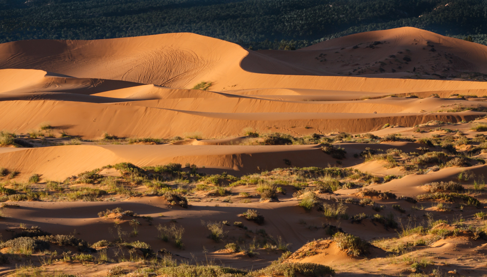 (Above) This is what the dunes look like at dawn, immediately after the sun rises over the nearby mountain.
.

(Above) Another sunrise “kiss” on one of the dunes, this one using a zoom lens.
.
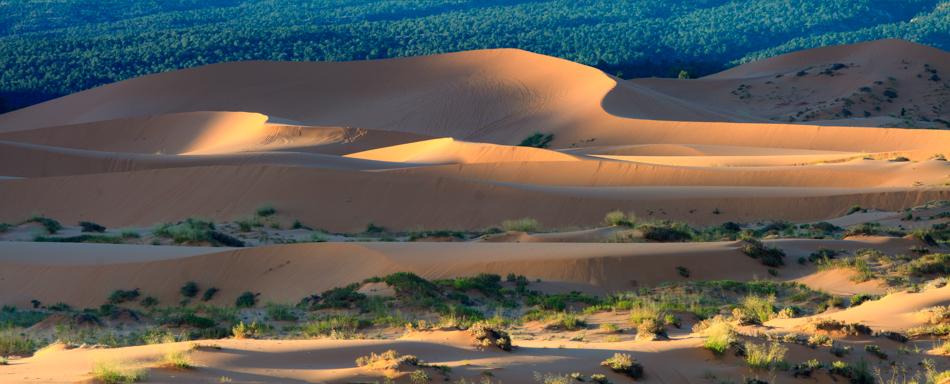 (Above) This is actually two separate photos stitched together using the panorama feature in Adobe Elements 10. I have some 5-image panoramas that would make fantastically big prints, but would be too long and skinny to display correctly on a website! The technique is pretty easy. Getting there before the sun is the harder part.
Twenty or thirty minutes later the light and colors were gone, replaced by Utah’s harsh sun and cloudless skies. Photos like this are available to anyone — providing that you can roll out of bed (or, in this case, sleeping bag) and get there before the sun!
.
Our trip to southern Utah coincided with a new moon phase. Having been out west before I knew that meant a beautiful night sky that we rarely, if ever, see on the east coast. It also meant that I had the opportunity to try some Milky Way photography — something that has been on my to-do list for a long time.
Preparations were fairly straightforward. I did some pre-planning by reading a few excellent celestial photography blogs, including David Kingham’s free online tutorials. I also had the good fortune of meeting and spending an evening photographing the Milky Way with Jon Fuller, a photographer who lives in Moab and has been published in National Geographic Magazine (among other publications). We collaborated with Jon and his wife, Paula, and both ended up with some fantastic shots in Devil’s Garden. Finally, I also downloaded a very cool free app called Night Sky 2 Lite to my iPhone. It allowed me to pinpoint where the Milky Way Galaxy would rise on the horizon, at 190 degrees south, between the constellations Scorpio and Sagittarius when we were there. (Note that the Milky Way rises at different times and at different places depending upon the time of the year and your location on earth. Early October was particularly convenient, as the galaxy rose shortly after sunset).
Although these are first attempts, below are four images that I particularly like, with my notes appended. The gas cloud that you see in the photos below is what gives each image a “wow” factor. Unlike the human eye, a camera gathers additive light for as long as you keep the shutter open. This allows you to see things that the naked eye does not.

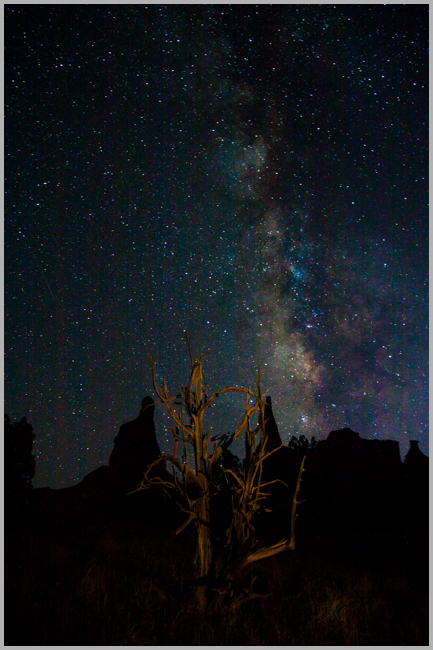
(Above) Location: Kodachrome Basin State Park, Utah. Exposure: 30 seconds; ISO 3200; Processed in Adobe Lightroom 4.
(Above) Location: Kodachrome Basin State Park, Utah. Exposure: 30 seconds; ISO 3200; Foreground “painted” by Melanie Snyder with a flashlight; Processed in Adobe Lightroom 4.
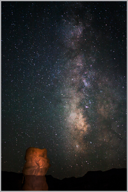
(Above) Location: Devil’s Garden (near Escalante), Utah. Exposure: 30 seconds; ISO 3200; Foreground “painted” by Melanie Snyder with a flashlight; Processed in Adobe Lightroom 4.

(Above) Location: Devil’s Garden (near Escalante), Utah. Exposure: 30 seconds; ISO 3200; Foreground “painted” by Jon Fuller with a very large flashlight; Processed in Adobe Lightroom 4.
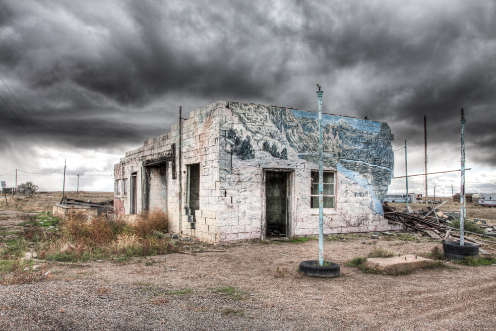
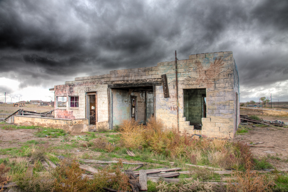
Melanie and I had planned our 30th wedding anniversary trip months ago — a trip to Utah / Arizona to visit five national parks and several national monuments and BLM areas over the first two weeks of October. Congress forced us to change our plans, and one of the pleasant surprises while adapting to the silliness of closing those areas was a photo session at a mostly abandoned town in Utah called Cisco. Most of the photos were taken with a fairly scary thunderstorm bearing down on us. Truth be told, this added an aura of spookiness that would not have been possible under typical Utah sunshine and blue skies.
Below is Melanie’s writeup about Cisco and several of my photos. The photos are heavily processed HDR images to accentuate the threatening clouds and dilapidated buildings.
In its heyday in the late 1800’s, Cisco was a “watering stop” for steam locomotives on the Denver and Rio Grande Western Railroad. It also became a livestock hub for cattle and sheep ranchers from the Book Cliffs, north of town. According to an online history of Cisco by Nancy Hazelet, at the turn of the last century, over 100,000 sheep were brought to Cisco for shearing before being shipped to market. Oil and natural gas were discovered in Cisco in 1924, and it became a drilling and mining center. But as steam locomotives began to be replaced by diesel and electric early in the 20thcentury, Cisco was no longer necessary as a watering stop, though the trains still ran through the town.
Cisco also used to sit right along US Route 50 and US Route 6, major east-west highways that ran from California to Colorado and beyond. But between 1957-1970, Interstate 70 was built along a new route that bypassed Cisco (along with many other small “hub” towns), and Cisco began to slide into oblivion, though it was assigned its own zipcode when the new postal zipcode system came into effect in the 1960’s. The faded paint on the façade of the town’s abandoned post office is only faintly readable “Cisco, Utah – 84515” A small freestanding unit of modern locked mailboxes stands right outside the post office building, and it looks like there must be a few people who still get mail sent here.
In the early 1990’s, parts of the film “Thelma and Louise” were filmed in and around Cisco.
Despite the desolation of the town itself, there are miles and miles of brand new pipeline being laid here. Cisco has one of the oldest oilfields in Utah. Pacific Energy and Mining Corporation, an oil and gas company headquartered in Reno, Nevada, operates the drilling fields here, including 5 oil and natural gas wells that the company started in 2005..
.
 .
.
 .
.
 .
.
 .
.
 .
.
 .
.
 .
.
 .
.

 (Above) This is actually a contrasty late afternoon photo taken shortly after we arrived. I like how the hikers provide scale to the image. As for hiking — well, I love hiking. But not in sand. In fact, it sucks. I’d rather take photos of other people hiking in sand.
 (Above) This is what the dunes look like at dawn, immediately after the sun rises over the nearby mountain.
 (Above) This is actually two separate photos stitched together using the panorama feature in Adobe Elements 10. I have some 5-image panoramas that would make fantastically big prints, but would be too long and skinny to display correctly on a website! The technique is pretty easy. Getting there before the sun is the harder part.


